This website is not intended as a map for a scavenger hunt. The locations of these structures have been left intentionally vague in order to respect the landowners and their property. With the exception of only a few sites, these caves are on private property. If you are interested in further researching these structures or finding any additional ones, please contact the property owners before doing so. These sites can potentially be dangerous and anyone who sets out to explore them should know they do so at their own risk. Additional images and/or information should be submitted to this website by the landowners or with their permission. In cases where neither is possible this needs to be explained.

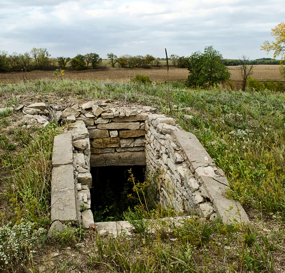
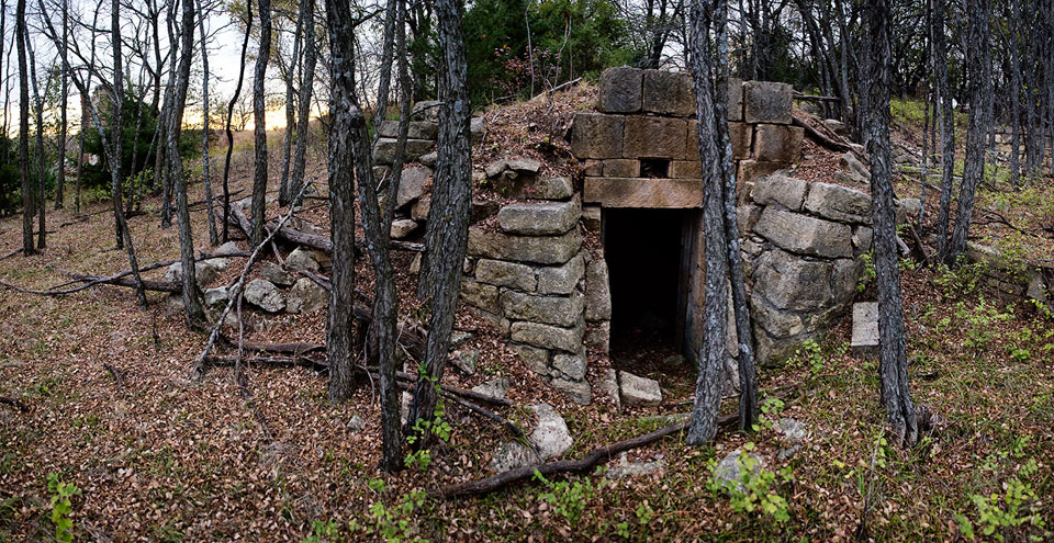
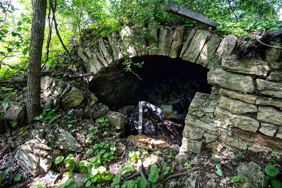
The images and information presented on this website represent the fruits of a serial exploration of native stone arched-roof, man-made caves that dot the landscape of the Flint Hills region of Kansas. These native stone constructions may have been built as safe havens by early prairie settlers before any other structures, e.g., homes, barns, outbuildings, were ever erected and are often all that remain of early homesteads and may represent the last traces of the people who built and relied upon them. The shelters exude a spirit or soul, possibly due to their resemblance to ancient crypts or religious holy places. The chisel marks on the native stone, which was harvested from local quarries or gathered from surrounding pastures, are like the lines on your hand, unique to each individual structure. These structures can be admired for their hidden beauty and importance to the lives of early homesteaders.
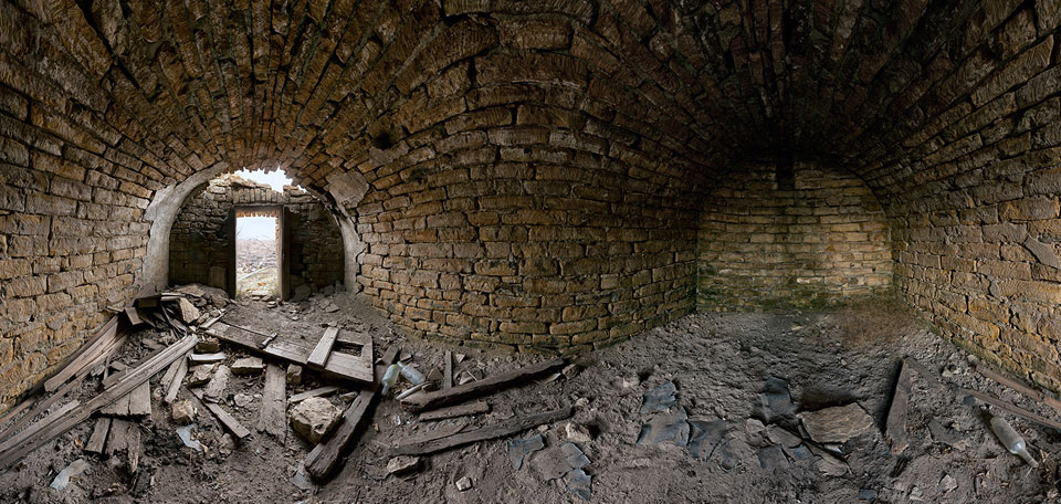
Much time has been devoted to researching and looking for these often-elusive structures. To locate them often required wandering the landscape in hopes of stumbling upon them, and talking to locals for leads. More than 270 of these structures have currently been located and documented with available historical information. Through photographic representation and careful research it is the artist's desire to preserve and present these structures in a new and visually stimulating way, using technologically advanced photographic techniques to create 180 to 360-degree impressions of their interiors. Each structure has been photographed in a standardized way, exposing its subtle, unique characteristics, documenting what has been left behind, and showing the fingerprint-like quality left by the people who built it. As a result of this technique, these hidden cavities become more like split-open geodes, revealing the beauty hidden inside
These were not large scale projects the likes of which entire communities, states, or even countries participated in and/or celebrated the creation of. Rather, they were often built by an individual and/or a family for the sole purpose of sustaining their lives and providing for their future in a time of crisis. Beyond their original purposes these places might have served other uses, too, e.g., they were likely the settings for all kinds of drama, as might be shown by artifacts that are still littering their floors. Other than these relics, about all that’s left of the people who relied on their security is this crypt-like cavity in the ground. It is hoped that visitors to this website will take the opportunity to reflect on their own role in the world, what they themselves have created or helped to create, and what legacies they will leave behind. Life is fragile and tenuous, and therefore we have lessons to learn by examining these humble structures.
This project started with the idea of exploring places of last resort or places that had become the last traces of a home or in some cases an entire town. Although this started with a broader set of possible structures as subjects (including bomb shelters, storm shelters, dugouts, etc.), the artist quickly felt drawn to dugout caves and root cellars like the ones shown here.
This attraction was partly due to the mysterious nature of the structures and how they seemed strangely similar to structures built millennia before them. Over time the fascination about them changed toward an appreciation of how the structures represent and are indicative of the lives of early pioneers and settlers of the Flint Hills which seems likely to have the greatest concentration of this type of structure apparently anywhere in the world. An ever-growing understanding of the significance of these structures to the early settlers of the Flint Hills has made these arched-roofed subterranean structures the focus of the project.

Clockwise from top left – John Olson Dugout, Mill Creek Township, Wabaunsee County; John Melgren Dugout, Blue Valley Township, Pottawatomie County; J.W. Alexander Root Cellar, Liberty Township, Geary County; Mary Condroy Root Cellar, Grant Township, Riley County.
Around the Flint Hills, these structures may have served in various capacities such as root cellars, spring houses, dugouts, cold storages and storm shelters, etc., and all often shared a similar pattern of an arched roof chamber made of native stone. They came in a few basic variations: built into hillsides or raised humps on flat ground. They might have been made of dry stacked or cut and jointed stone. They could have been used as a home, or strictly for storage, or for any number of other uses, but often as many things during their life span.
They were often incredibly difficult, even painstakingly hard to locate. The project has required many hours researching and doing whatever was required to find the structures, sometimes just wandering the landscape in hopes of stumbling upon them, and at other times talking to numerous people in order to find any possible leads. In the end though, more that 270 of these structures have been located, more than 225 of them have been photographed, with more than 55 photographed using the unique photographic techniques developed for this project. In addition to a new and visually stimulating representation of the structures it is also the purpose of this project to continue to uncover any history that exists about them and to discover whatever can be discovered about their uses and importance to the region of the Flint Hills.

Whiskey Lake – Cold Storage, Jefferson Township, Geary County (this image and next). These structures are at times the only structures remaining of a whole town. None demonstrate it better than this one which is the last remaining structure standing in what was Whiskey Lake, a small town south of Fort Riley, Kansas, near what is now Marshall Airfield.

This image was one of the first shot as part of this project. It shows a full 360 degree image which shows both the front and the back of the structure. It was made up of only a few hundred images. As I worked through the best way to shoot these spaces, I quickly discovered that each of these structures had its own unique set of challenges that I needed to respond to in order to get the shot the way I wanted. This structure was especially difficult due to its very small size (about 4 ft tall). I had to crouch for hours while I shot it. Eventually, I ended up reshooting it 3 times trying to figure out the best method.
(In the words of the artist) My first encounter with a structure like these happened as a pre-teen youth playing “army men” with friends in the pastures by my home near Tuttle Creek Reservoir, in Riley County, Kansas. While we chased each other from rock-to-rock and tree-to-tree yelling “bang-bang” and “I got you,” we stumbled on a mound that turned out to be one of these arched caves. At the time, and really until just recently, I had no idea what we had found. My three companions and I were actually quite startled by what we discovered and didn’t understand why something like this would be all by itself in the middle of nowhere. Our imaginations swirled and we started coming up with frightening reasons for its existence. Was it some kind of prison, a tomb, or an Indian hut? We were too scared to enter, but would dare each other to run across it or walk down inside of it, never to do either for very long due to the thought of falling in or becoming trapped. It was dark inside and full of untold creepy things so for the most part we stayed away from it and eventually forgot about it. I returned where I thought this cave was recently and only found a pile of stones in a shallow hole remaining.
N.T. Dameron Root Cellar, Newbury Township, Wabaunsee County. This cave most closely resembles what I remember the first cave I encountered looking like. Although, the one I found as a kid was covered in the tall grass.
Much more recently, not long before going back to K-State to work on my MFA, I discovered that a friend of mine who lived on Moro Street, Manhattan, Kansas, had a rather strange addition off of his basement. It was a cold storage used at one point (according only to hearsay) to keep beer kegs cool at what was a midway bar between Poyntz and Aggieville. Men would stop at it to get a beer on their ride between the two early social centers of the town, replacing the one they’d depleted. Upon being shown this cave I immediately wanted to photograph it. Not only was it the first of these cave-like structures I was to spend a significant amount of time in, but it was also one of the first images I made using multiple images stitched together. Around this same time I started to play with panoramic techniques in other places, too. I had finally made the switch from film to digital photography and discovered it had the potential of doing what film photography rarely did well, i.e., stitched imagery. This seemed to free me from the restraints of my lense or camera’s angle of view and I started to see how it opened up the possibility of expanding my ability to capture a scene the way I wanted. I wanted to take full advantage of what digital photography offered. Unlike my current series, the image of this first cave was less than 180 degrees and showed only a small portion of the floor and ceiling. It also was shot with existing light from the back window, but was not done to show anything but the darkened space. The image was made up of about 100 pictures that were roughly stitched giving it a kind of shifting focus effect and could be printed to 4’x6’. The picture itself ended up either looking like a first-person view through the eyes of someone about to be locked in a dungeon, or even more so, like someone being finally released. This image sparked the idea of trying to find more “caves,” but I never thought I’d find very many. And I also was still looking at these as places of trepidation and potential scenes from some horror movie.

George Washington Sigman Root Cellar, Manhattan Township, Riley County. This image was taken of a Cold Storage that was built under a house that a couple of my friends lived in 06-07. I believe that judging by the large back window that it was clearly a cold storage and the window was used to put ice into it. I found the room to be full of potential and tried with this picture to encapsulate the emotion of either imprisonment or release from imprisonment.
This was where I started with the idea of finding and photographing places like this. At first I was interested in any places of last resort that I thought were or would end up as the last remnants of their owners. As I searched for such places and started to find more of these native stone arched roof caves I decided I would concentrate on them and make the work about a compare-and-contrast study of what I found. I spent much of 2011 looking for and finding what turned out to be a surprisingly large number of these structures and started to become somewhat obsessed with them, especially as I discovered just how special it was to have them in the kind of concentrations they are in around the Flint Hills of Kansas.
G.W. Engstrom Root Cellar, Liberty Township, Geary County.
I think my initial impulse as a kid, to find these structures frightening to the point of avoiding them or at least not wanting to go inside for very long or not at all, was a natural one that would be quite common. After all, these spaces are generally small, dank and dark, and would seem without inspection to surely be the home of who-knows-what kind of insects, animals, and/or pestilence (sometimes this actually proved to be the case – I found 3 nesting vultures, a number of pack rat nests and a myriad of types of mold within them). I think that’s partly why in all my research on the subject I’ve found so little documentation about them. Even when discussing these structures with archaeologists from the Kansas Historic Society they said they had little to no information about the subject, only stating whether or not a root cellar of any kind existed on a property they surveyed without offering any description of it. Even as a young teen that loved the idea of being an archaeologist myself, and even having read multiple books on the subject, this lack of available information regarding these structures did not make me want to investigate these spaces any further.

Nesting Vulture inside of W.S. Cooper Root Cellar, Pottawatomie Township
Later on, after high school and as a photo undergrad at K-State, I would spend time looking for and photographing old, abandoned houses and buildings in an attempt to find the beauty in the rot and rubble. But, even then, I would never do more than peek into a root cellar under a house or in an adjacent lot. Of course, this was partially due to it being restrictively dark, but also because they just tended to give me the willies. It wasn’t until I had the chance to go into my friend’s cold storage that seemed innocuous due to it being adjacent to their living quarters, that I started to see the potential for these spaces. Even then I would treat it like so many of the buildings I would explore, photographing like I was scouting locations for a horror movie. Their dark spaces just tend to repel a person from entering them.
These rather humble structures also seem to exude a kind of shrine or cathedral-like quality similar to the mysterious megalithic stone structures that dot the globe. They truly seem strangely similar to structures such as beehive huts in Ireland, passage graves and Souteraines in Scotland, Si’s in Croatia and Greece (including Agamemnon’s tomb), as well as numerous other dry-stack stone structures that I have seen in books on ancient cultures. It really made me wonder how these Kansas structures would be interpreted if found thousands of years from now by people without any historical context. More than just this seeming similarity to the other structures mentioned above, I discovered and thought the true wonder of these structures was to be found in the fact they were truly unique and indicative of the life of the early pioneers of the area and spoke of the conditions they lived in and the geography that they subsisted on and had to contend with. This special relationship of homesteader and this structure and the fact that these were likely the last remnants of these people made me decide to shift my purpose again from purely trying to aesthetisize these structures to more of a serial project based on the documentation of them.

An ancient Trim structure in Croatia and a megalithic passage grave in France.
This documentative aspect of the work has substantially increased since being awarded a Kansas Humanities grant in order to help push the work further. So, I began by trying to drive out any fear I had of the spaces no matter what condition I found them in or where they were located. At first I attempted a number of methods of photographing them in order to find the best way to aesthetisize them as unique individual images or later as the archetypal/common structures they were in hopes of showing the organic quality and primordial beauty I had started to find in them. My love of history and the idea of search, discovery, and documenting of little known and somewhat mysterious structures has become a great joy for me despite the difficulties involved. Actually, as I shot more and more of these structures, I started to feel quite calm in them, even as I would have to spend upwards to 5 hours or more inside of them getting the shots I needed, often crouched or hunched and likely feeling terribly uncomfortable physically. But, they each gave me time to collect my thoughts and to think and meditate. Although at times they were quite creepy too.

Joseph Zabokrtsky - Root Cellar, Little Blue Township, Washington County. Early attempt at shooting locations based on responding to specific location in order to find best vantage point.
I developed a method of photographing the structures in a way that demonstrated the commonalities between them while bringing out each structure’s uniqueness which came from the method of its construction, the type of stone used (geology of the area), the method of rendering the stone to size, the toll/wear that time and nature had taken on it as well as the aura of the space produced by the combination of these elements and the direction and temperature of the light entering the cave. Soon my interest turned to more of an obsession, and what had been a desire to try and find beauty in their dark, foreboding spaces became a passion for photographing in such a way that served to reveal these hidden archives for others to discover them as I had, a sort of fossil left behind by the early inhabitants of this area.

Joseph Zabokrtsky - Root Cellar, Little Blue Township, Washington County. Final version of structure after deciding to treat each structure equally.
Of course the first thing I had to do was find these structures. This started with a lot of driving around looking for their telltale signs of rocky outcroppings, raised mounds, and/ or entrances into the hillsides; or investigating abandoned houses and looking to see what kind of root cellar (if any) they might have had. I found a number of them this way, roughly half of the first fifty (plus) I was able to locate. I would map spot each, shoot scouting pictures, and would record what directions they faced so I’d be able to prepare better for them when I came back to shoot them. I also placed an ad on Craigslist looking for them and actually had little luck. Once I determined, however, that this was going to be mostly ineffectual I started to pass out flyers and leave them in mail boxes as I scoured the countryside. This approach, and generally trying to find them through word-of-mouth, ended up paying off with an additional dozen or so. Talking to historic societies surprisingly didn’t turn up any, at least not right away. Few of the historic societies seemed to have any record or knowledge of these structures’ whereabouts. When they did, though, they were located as part of historic buildings that were being maintained. I had decided one of my criteria for the structures I would photograph was that they were either completely abandoned, or that they had been left to the elements for some time (possibly in the long term I’ll return to the others for further comparison).

C.G. Carlson - Root Cellar, Blue Valley Township, Pottawatomie County. Example of very isolated structure that was found by looking for rocky outcroppings while out driving.
What did end up paying off most of all was when I found someone that took an interest in the project. In fact, I had three people that were especially helpful and led me to find fifteen of the first fifty that I located. These were mostly in Wabaunsee and Geary Counties and were definitely ones I would have never found on my own. As with most that I found, these structures were the only things remaining of homesteads and as such were often incredibly difficult, even painstakingly hard to find. Some of the difficulty arose due to the differences in how roads were laid out in comparison to how the original plots were laid out. More specifically, I found that where roads are had little to do with where these places were located. Hence, many times I had to hike to the middle of multiple full plot sections in order to try and find one that I heard about. There was no guarantee I’d find anything. I then got wise and started using Google maps to investigate such places I heard of first, before going out to find them. In addition, I had to coordinate with property owners and my own busy schedule to find time an opportunity to shoot these structures.

These maps show the area in which I conducted my search around the Northern Flint Hills of Kansas. I thought I might find 25 or so when I started out. In fact, though, I found about 125 by the end of my Thesis project, and now have located more than 270, most of which are located in Riley, Wabaunsee, and Pottawatomie Counties.
These maps also show the concentration of the structures around the hills of Riley County, Kansas. Similar concentrations were found in other areas around the Flint Hills. Was this due to the nature of the German, Swedish and Scottish immigrants that settled the area? Are these structures an extension of these cultures? It’s likely that there were cultural influences in these structures, but the markers in each also suggests subtle differences that make them unique as well.
These arch-roofed, stone structures present us with many questions. Who built them, and when? What were they used for? How were they constructed? The answers to these questions elude us. Because these structures were part of everyday life, many people who built them saw no need to write about them. Most settlers to the Kansas frontier, if they wrote memoirs at all, probably did not consider their cellars a subject to write about in detail. Despite this, there is evidence that can shed light on the origins of these mysterious structures.
At first glance, these buildings seem similar to other ancient stone structures or even megaliths found in other parts of the world. The chambered tombs and passage graves of the British Isles; Cairns and Souterraines of Scotland; Bee-Hive Huts of Ireland; Cairn structures from coastal Croatia, Greece and the islands of the Mediterranean; as well as the Fogous of Japan; share similar visual elements with the arched-roof cellars of Kansas.
Clockwise from top left: Portal Tomb in Orkney, Scotland; Beehive Hut in Ireland; Fogou (hermit house) in Japan; Souterrain in Scotland’s Isle of the Skye
This is probably coincidental. The arched-roof cellars of the Flint Hills are likely an independent innovation. While these buildings are visually similar, there is no evidence to link them directly. The presence of the arched roof is also unique, as most of the older structures from elsewhere in the world used flat slab roofs, and some were circular rather than rectangular in design. Although the visual similarity is striking, the people who created the arched-roof cellars of the Flint Hills were unaware of similar ancient stone structures from around the world.
The history of early European colonization of New England presents one significant piece of the puzzle. English colonists arriving in the early seventeenth century experienced a more extreme climate. The temperatures in Chesapeake Bay could swing from 10 degrees Fahrenheit cooler to as much as 20 degrees warmer than temperatures in Great Britain. Humidity in the colonies was also higher, especially in the south. This more extreme climate made food storage difficult.
To solve these problems, colonists learned methods of long term food storage from Native Americans, who had long devised ways of dealing with these issues in the American climate. The most significant of these methods was the underground storage pit or cellar house. By digging “subfloor pits,” also called “cooling pits,” under their houses, Chesapeake Bay colonists could keep root vegetables and other foodstuffs cool in the summer and warm during winter.(1)
Cellars existed in England, but were somewhat rare and not usually used for food preservation. A study comparing housing in East Anglia, England, with that of Suffolk County, Massachusetts, shows that from 1635 to 1749, only about 4 percent of houses in East Anglia included a cellar. From 1630 to 1660 in Massachusetts, 50 percent of the houses included cellars.(2) Cellars were more common in America, due to the extreme climate and Native American influence.
Although the concept of using cellars for food storage can be traced in this way, the arched-roof structures of the Flint Hills of Kansas are not necessarily a direct descendant of this tradition. Many of the European settlers to Kansas were not necessarily descendants of original New England colonists. Many came directly from of Europe and brought their own heritage, skills, and traditions. Some of the arched-roof cellar structures found throughout the Flint Hills are indeed underground cellars, but many others are free-standing, partially or fully above-ground buildings built into hillsides, embankments, or dirt mounds. The origins of these buildings are much less clear. Due to the lack of any mention of root cellars prior to 1609 (Gage) it seems possible that the Native American technology made it's way back to Europe and was incorporated into the homesteads of these other european cultures which in turn adapted their own building styles in their design. In the late eighteenth century, colonial American journals and advertisements begin to reference “root cellars,” “root houses,” or “Dutch cellars.” These descriptions indicate a type of free-standing structure similar to those found in the Flint Hills, with the exception of the arched-roof feature. Whether these eighteenth century cellar structures are connected to the cellars of the Chesapeake Bay colonies – and whether either type is related to the Flint Hills structures – is questionable.(3)

These are two of only six arched root cellars of any type that James Gage was able to find in all of New England in 15 years researching the subject of root cellars. I’ve found well over 270 in 2 years in little more than 4 Kansas counties. New England cellars are rare and generally limited to wealthy land owners. Like most other dugouts and external cellars, they would have likely been built first and lived in while the land owners built a proper house.

J.O. Easterberg Dugout, Centre Township, Riley County.
In 1854, the United States Congress passed the Kansas-Nebraska Act. This bill created the Kansas territory, opening it for settlement. At the time, friction between slave states and free states was incredibly high, and many Americans were preoccupied with the question of whether Kansas would permit slavery. The act left this decision up to a popular vote – settlers would move into the newly formed territory and vote on whether Kansas should allow slavery or remain free.
Settlers on both sides of the issue raced into Kansas to establish themselves and push for the creation of a state government of their preference. Violence broke out between pro-slavery and anti-slavery factions in a period of strife known as “Bleeding Kansas.” While many of these settlers attempted to build local government, they also built root cellars. Settlers from other parts of the world poured into Kansas, bringing their unique cultural traditions and skill sets to the prairie.
Germans and Swedes made up the largest groups of immigrants to the Kansas Flint Hills in the mid 1850's and 1860s. Welsh immigrants also moved into the area around the same time. All of these groups exhibited a high degree of masonry and stone-working skill as a part of their cultural heritage. Many of the original stone buildings and fences built by these settlers can still be seen today in areas within Wabaunsee, Geary, Riley, Pottawatomie and Chase Counties.(4)

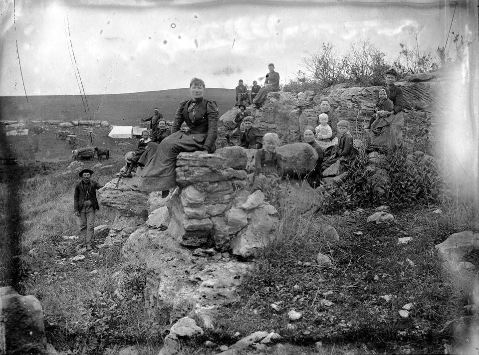
Davenport girls climbing on rocky out cropping, Wabaunsee County. This image illustrates the nature of the Flint Hills terrain. At the time of the areas settling there were very few trees but an abundance of rock at or near the surface. Many properties would have their own private quarry to draw building material from.
Settlers near Hinerville, Wabaunsee County soon after setting up camp on new claim. Image shows the nature of the landscape for theses early settelers. Notice the tent in the background. Families might live in such a temporary shelter while building something like a dugout cave or a log cabin to shelter them through the coming winter and in some cases many seasons to come
The vast, flat grassland encountered by these settlers lacked timber. Prairie fires, blazes set by American Indians, had rendered the Great Plains treeless. Tribes of native peoples had different reasons for using prairie fires, but most included controlled fires for communication and war. As a hunting aid, they influenced movement and migration patterns of bison through fire and smoke. Fires improved pasture quality, which also affected Bison movement. Hundreds of years of these practices had rendered the landscape virtually treeless at the time settlers arrived to the area.(5) The Flint Hills region in particular was short on lumber, but had a plentiful supply of stone near the surface.
Many of the German settlers to the area were Russian-Germans, German families that had immigrated to Russia in the past, and represented a blending of these two cultures. These Russian-Germans were primarily from the Volga region, near the Black Sea and the Ukraine. In the late nineteenth century, political changes in Russia, an economic downturn, and a series of famines led Russian-Germans to immigrate to the United States, concentrating particularly in North and South Dakota and Kansas.
The geography and climate of the Great Plains was similar to the Russian steppe, making Russian-German building techniques particularly applicable to Kansas. These settlers clung tightly to their traditional architecture styles and construction methods and tried to avoid American influences. The scarcity of timber in the region was true of their homeland as well, and they made use of a sun-dried brick-and-mortar technique known as Batsa. Their traditions, including extensive use of cellars, did not usually feature the arched-roof style, but instead used a gable roof.(6) However, some settlers did occasionally make use of arched-roof structures, such as the large cellars built by German immigrants to Cincinnati and St. Louis in the 1850s. These were primarily used as icehouses for brewing and storing beer.(7)
These arched-roof structures were able to serve multiple roles for homesteaders. Although most were built as root cellars or storm shelters, their first use, even in the New England Area (Cage), but especially in the sparsely populated frontier, might have been that of a dugout home. These structures would offer top-notch security for the settlers from the weather and make the wild swings in temperature tolerable. Kansas was then, as today, tornado alley so being able to have a refuge from extreme weather, a storm shelter, was paramount. These structures would often be built first and lived in for the first year or two while a generally modest home was erected. At that point the structure would go from a home, protecting the very lives of the settlers, to a shelter for their food stuffs through the changing seasons. This was especially the case among the Swedish and German settlers of the Flint Hills. It would always remain the storm shelter in times of need. Other functions these structures would have served ranged from that of spring houses, built to protect a spring on a settler’s property and to help provide water; a sistern to gather rain water; a brick kiln; and even a bread oven. These were truly important utilitarian structures/items for these early homesteaders.
Much is still unknown about these structures, mostly because few records exist about their construction and use. To the average Kansas settler in the mid-nineteenth century, details about their cellar or storm shelter probably did not seem notable. However, we do have some sources that shed light on who built these structures and what they were used for. One very detailed story comes from Agnes McPeak, who was just a child in the late 1800s. She recalls that on her family’s property was,
"an arch cellar, the stones pigeoned holed or dove tailed as it was sometime called. It was built in 1894 by the same stone mason who built the strong stone wall of the cow lot. It still stands. . . . A wooden roof was built over the arch cellar (this is long gone). There was a small pipe for ventilation through the roof. This cellar was the storage place for our dairy products. It was also for vegetables, such as potatoes or apples or turnips. In summer it was very cool in this cellar. A large thick door, also a screen door was erected. There were three steps down to enter. The cellar was a refuge in severe electrical storms and high winds. Mother would light the lantern and she and we children would go hand in hand to the cellar and wait for the storm to abate."(8)
An anonymous journal from Clinton, Kansas from a woman born in 1909 demonstrates how prevalent these structures were by that time, noting, “We had a storm cave close to the house. . . . I don't know who first dug and built the cave or for what purpose. Caves were used both as storm shelters and as a place to store fruit and vegetables. Such caves are still prevalent in many places.”(9)

This is a Nebraska Dugout made from Nebraska Brick, Basically a sod dugout. Likely a common type of dugout in much of Nebraska where soil tends to be deeper.

These are more images that show different forms of Dugouts around the country. Cellars also share this same diversity and seldom use the fully stone variation of the outdoor “cave”. I think these help illustrate the variety of forms these take and the way that form not only follows function, but is also determined in large part by what materials are available.

This is generally what people expect to see when thinking of a dugout - nearly all the images I was able to find showed these types of structures to be located out in Western Kansas. Image thanks to Kansas State Historical Society.
The 1879 diary of Elam Bartholomew describes how many settlers used these structures. He writes,
"We found rather an odd but perhaps a very advisable practice in vogue among the citizens of the town which was that the principal part of the people had made little dugouts or caves near their homes that they might fly thither in case of the appearance of another tornado; we were told that many of the people, during the latter part of the season, would fly to their little dugouts whenever a little thunder shower came up."(10)
Newspapers from the period also demonstrate the widespread use of these structures as storm shelters. The May 22, 1896 issue of the Wichita Daily Eagle records a storm that spawned “Seven Cyclones at least,” and that many families and individuals “saved themselves by getting into caves.” These “caves” are likely these same arched-roof structures, as the article describes one family who endured the storm “in the cyclone cave and escaped without serious injury, although the cave was unroofed and some of the arch stones fell into the cellar.”(11)
Nearly a year later, in April 1897, the Eagle reported that another tornado had inspired the construction of over 1,000 storm caves in Oklahoma. The paper printed an article that described the “Best methods used in building the refuge from the whirling enemy of mankind – Above everything else they must be staunch and strong – Best location is to the southwest of the dwelling.”(12) Many of these structures are described as being fully underground. However, most of the Kansas structures are at least partially above ground.
The Flint Hills stone caves were used as far more than just storm shelters. They were useful for food storage, and also served as homes, sometimes temporary and sometimes long term. Theodore Weichselbaum, a settler to the Ogden area in 1856, recorded his experiences in 1908. He built underground cellars as breweries, but later repurposed them for grain storage and stables.(13) Some settlers used them as a smoke house for cooking, or even for bee-keeping.(14)
Strangely, there was very little to be found about the arched roof structures in the area of the Flint Hills (or anywhere else for that matter), although it seems clear that their purpose had similar origins as these more commonly documented forms of dugout structures. It seems likely this was in large part due to the time period various areas were settled. The sod houses depicted here were likely built later than the more permanent stone structures of the Flint Hills. More photographers and better photographic equipment were available when these dugouts were built and inhabited, so these are more commonly seen in photographs.

This photograph not only shows a pitched roof partial sod dugout, but also shows how many people might share a small space like this. This is seemingly the most common form that dugouts took in Kansas judging by the number of images I was able to find showing them. Image thanks to the Kansas State Historical Society.

This image illustrates the fact these structures were likely packed with people as well as belongings, and it makes me think that that people would have slept outside whenever possible. I imagine that the arched roof dugouts would have been similarly filled. Image thanks to the Kansas State Historical Society.
Several family histories from the Bluestem Prairie area describe the construction of these stone cellars and how many families lived in them until other more permanent homes could be built. The Carlson family lived in their dugout home for eight years until building a stone house. The Hanson family built a large home in 1880, but before then “they had lived in a dugout for several years where their oldest children were born.” The Pishney family had a similar experience. “Their home was a dugout which is now a cave on the Loren Smercheck farm.” The Bloomquist family also lived in their stone cellar. “They each dug caves to live in until a house could be built. The advantage of living in a cave was the temperature was the same winter or summer.” The Parker family purchased land and found that a previous occupant had already constructed “a cave with an arched limestone interior and a chimney in the far end made in the side of the hill.” (15 - Refer to the George Parker cave in the location list for images.)
One of the most detailed accounts comes from Mrs. Hattie E. Lee, who was born in 1868. She describes how her family used the original stone structure as other buildings were later erected around it in the 1880s. “The family never lived in the frame house; we used the first stone house and attic to live in. . . . The frame house was built over the dugout and the dugout was used as a cellar to store things away in. We still used the stone room for dining room and kitchen.” She describes the use of a stone storm shelter and cellar in 1902, saying, “In July, 1902, the children were playing out and Will ran in and said, ‘Oh, Mother get into the cave quick a bad storm is coming.’ I closed the house and we ran to the cave dug in the bank of the slough. . . . There was only a screen door on the cave – it was just a small place near the well to keep our cream and butter cool.” It is unclear whether this is the same structure from when she was young.

Along with sod construction, this type of structure seems to be the most common form of dugout home in Kansas. Image thanks to Kansas State Historical Society.

Francis Eugene Murphy is shown on the porch of his ranch house located in Haskel County east of Santa Fe KS Also visible at right are a storm cellar or fraid hole and a windmill Murphy owned 100 quartsecs. Did this "Fraid Hole" start off as a dugout home? Image thanks to Kansas State Historical Society.
Lee relates stories of many other settlers she encountered who also lived in these structures.
"Early in the spring of 1873 two Swedish-speaking families from Galesburg, Ill., came to Osage City . . . . The fathers, Magnus Lungren and John Sutherland . . . immediately built a one-room shack. In this roughly built but the two families lived together for several months [sic]. Towards fall Lungren made a cave on his farm. In this cave the young Lungren family lived for several years."
Other Swedish settlers had similar practices. Lee describes, “The Swedish-speaking settlers who came to Stotler in 1874 . . . . [such as] Swan Lundholm, Andrew Chelberg, and C. I. Johnson, all of whom built caves as their first Stotler homes.”(16)
Link to interviews regarding their many uses: Click Here
Signs that the Flint Hills arched roof structures might have been used as dugouts during their tenure
include having large windows in the back or sides, facing south or maybe any direction other than north,
having a single entrance opening straight out to flat ground, remnants of household objects left in the structure, and most of all, stories passed down about them. 
J.O. Easterberg Dugout, Center Township, Riley County. I just recently found this place and was amazed by what I found. It’s a kind of Holy Grail to me.

These images show another place I recently found that seems to further illustrate the fact that these were used as homes. From the outside it seems like many others, but on the inside it had some really special features which don’t fit the idea of a root cellar. An interior wall with a doorway separating it into two rooms and a really large back widow. Clearly this was also a space for people to live in.

This picture is the only picture of a dugout that seems to show one of these types of structures.
It’s impossible to say with certainty that it is a native stone arched roof dugout, but I think it’s likely.
This dugout was located somewhere between Manhattan and Wabaunsee, Kansas. Image thanks to the Kansas State
Historic Society. - When researching the topic of root cellars or dugouts, etc., I was really astonished by the lack of any images of the particular type of structure that appears so often in our landscape. This image is the only one I found that seems to show the type of structure in question. For whatever purpose they were created, it seemed to me that they were surely important enough to have some research conducted and images recorded about their use as homes or even as common cellar. I did end up finding similar, but obviously visually and structurally differing structures throughout the country that did have some photographs and research available about them. I’m pretty certain that these arched structures had similar origins as these more commonly documented forms of dugout structures. I was told this was in large part due to the time period various areas were settled. The sod houses depicted in the previous images were likely built later than the more permanent stone structures of the Flint Hills. More photographers and better photographic equipment were available when those dugouts were built and inhabited, so those end up being more commonly seen in photographs.
Why would the Flint Hills structures be built of such permanent material? It doesn't seem likely that this was because the early settlers expected to live in the area for generations. It was about making the best use of their skills and resources, and the likelihood that the builders were potentially very forward thinking enough to know that the structures would have continued usefulness even after they stop living in them. Was it about permanence like the stone buildings at Kansas State University, or was it making the best of what resources and skills they had at their disposal? It seems much more likely that it was the latter. It seems doubtful that the settlers were thinking they wanted a structure that would last for millennia. It's likley most weren't confident they would be in the area for very long at all.

These images shot by Alexander Gardner around 1867 of Manhattan illustrate the lack of wood in the area. Stone, however, was plentiful!

This image shows Manhattan in 1883, 20 years after its settling and still so few trees. Just think about it now – Tree city USA

It truly is about the right combination of resources and the skill set of the pioneers – This image shows how the bed rock came right to the surface and how settlers wouldn’t have to dig far to find large rocks suitable for building. Also, just picking up stones off the surface of the prairie to use for building was like killing two birds with one stone. Clean off the pasture and gather building materials.
For quite a long time I was unsure of just how these stone structures would have been built. When I asked people about them who had one on their property or knew of them elsewhere, I seemed to get a similar story as to just how this might have happened. For instance, some claimed they were built over a mound of dirt. This seemed logical enough until I was set straight by a mason who told me that this would make no sense. Dirt would be subject to compaction and settling especially if it were wet. There was more than likely a scaffold or support system in place. Could someone have actually used the dirt method? What if the dirt was actually shaped from the existing compacted rocky soil on the spot and so it had already been compacted for centuries or millennia before the attempt to build over it? Some do seem irregular enough to think this might have possibly been the case.

The use of scaffolding was illustrated in a book by James Gage on the history of root cellars. The author sent me these two diagrams/blueprints that illustrate just how it was done. I’ve also recently spoken with a mason who is actually building one and has been using a form like these to do so.
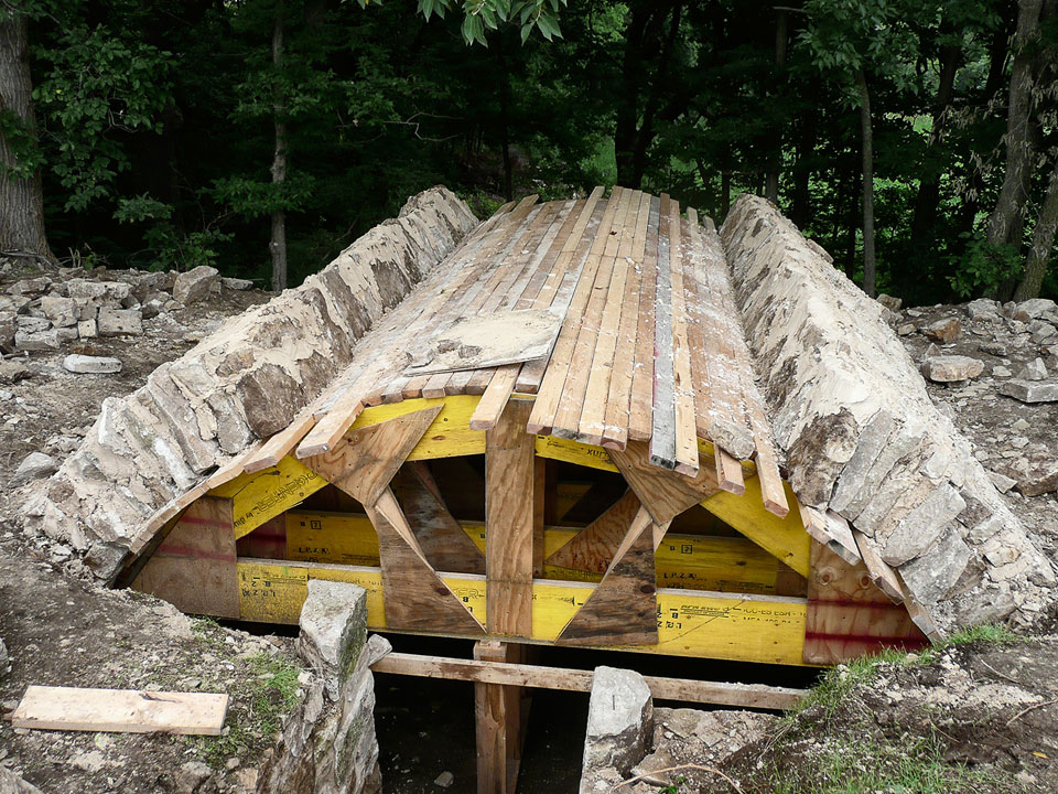
August Brasche Root Cellar, Washington Township, Wabaunsee County. This image was taken of a recent project done by Luke Koch and his Masonry Company. It illustrates how the scaffold would have been covered with some form of paneling, which would have stayed in place until the final keystone was placed in position. I do wonder about the level of skill that each would-be mason brought to construction of a particular shelter. Did the home owners themselves build some of these structures without the help of a more skilled mason? Drawing from previous exposure (i.e., past experiences), they might have had certain insights regarding how to build a dugout that was most helpful especially in the early days when there might not have been a large pool of skilled masons to draw from. This might answer the question as to why there is such a diversity of stone work found throughout the structures. I’m sure that not too many could have been as skilled as Luke Koch the builder of the structure depicted here. It also was apparent after visiting this site that these projects would have been intense and could have taken a few months to complete. August Brasche Cellar Restoration by Koch Construction Specialties
I do think that some of these structures were built by much less skilled craftsmen than others. Possibly even some were built just from a memory of seeing a similar structure built in the builder's home country. As you look at the variety visible in the way their stones are laid out and how their stones were apparently quarried you can tell some were much more primitively built than others. I came to understand that it was likely that the settlers would trade their handiwork with each other and even at times, especially around Fort Riley, the government would contract skilled masons to go out and build robust arched caves in order to incentivize the homesteaders staying in the area. Many of these are made using huge, possibly machine-cut stone that is clearly jointed with mortar. Most of these I found in the McDowell Creek area south of Fort Riley. Further away, around Alma and other areas not near the fort, the use of the dry stack stone method is much more common. These methods used no mortar for jointing, but instead counted on friction and gravity to do the work. Later, many of these would have had mortar injected in between the rocks and even given a whitewash of lime plaster in order to avoid water seepage and mold.
The methods for constructing these buildings remain a mystery. While some of the stories above refer to the hiring of stonemasons, some settlers attempted to build the stone structures themselves. The Flint Hills area provided plentiful natural stone for building material. Some settlers, such as the Poole family, were able to quarry stone from their own land.(17) As one early Wabaunsee County homesteader recalled, “I got out stones for a cellar and had to haul them four miles. I dressed them myself and lay up the walls of the cellar and it is still standing. I built a house over it of native lumber.”(18)
Clearly these structures are versatile and stand as a testament to the ingenuity of the original settlers to the Flint Hills region of Kansas. They are an important part of the cultural heritage of the varying origins of those pioneers, and provide key insight into their lifestyles. Much is still unknown about these structures, and they continue to provide a sense of beauty and mystery about the past.

The structure on the left shows clear signs of being built with wood form in place, as do many others.
It features a very regular and smooth arch, as well as signs of the mortar squishing out at the bottom of
the jointed stones. The dugout on the right, on the other hand, seems to show signs of the dirt mound method
of building. Some do seem irregular enough that this might have been the case, although it’s still clear this
would have been the exception and not the rule. After meeting with a local mason and going over some of my
images he seemed pretty convinced that some really showed signs that they could have been built over a dirt
mound. Not only do the structures with irregular arches seem unlikely to have been built over a rigid form,
but also show excessive irregularity in sizing and coursing of the stone (especially around the bottom). This
suggests that the builders were likely blind to the way the stones at the bottom of the spring walls would have
looked and therefore might seem even more irregular.

This shows that the plaster or cement coating might have come many years after the original structure was built. The cement or plaster would have helped keep rodents, insects and mold causing moisture out of the space.
From an interview with Margy Stewart, local historian from the McDowell Creek area of the Flint Hills, “In the early
years of the settling of the Flint Hills there were often many more people living in some of the now rural areas than
there are today. It used to be that farmers bought or were awarded quarter, half, or full sections. Notably, a quarter
was 40 acres, a half was 80 acres, and a full was 160 acres. So at some point you would have had much of these areas with
a small homestead just over a hill or clearing from each other, one every 80 acres on average, often with 13 or more
children in hopes that some would survive, often with a dugout. Often these smaller plots were quickly consolidated and
were owned by single families. This made it so that many people found themselves needing to move on or to work the land
for others. Then there is also the thought that the grass is always greener which would drive many homesteaders to cut
their losses having decided that the terrain was too rugged, or maybe just heard of a better opportunity elsewhere. This
would drive many more to leave these areas." Interestingly, nails were so rare at times to early pioneers and settlers that they might burn down their own home in order to reclaim the nails before moving on to the next settlement. This might help to explain why there can be so little found accompanying some of these stone chambers. That and the fact that many settlers might not have ever built more than a simple dwelling like these caves before dediciding to leave or simply selling the property for a profit. In the book “Ghost Towns of Kansas,” it describes the fact that there were
over 5,000 communities around Kansas that went from boom-to-bust during the first 50-100 years of its life as a territory,
and later as a state.
Footnotes:
(1) James E. Gage, Root Cellars in America: Their History, Design, and Construction 1609-1920 (Amesbury, MA: Powow River Books, 2009), 2-3; Donald W. Linebaugh, “All the Annoyances and Inconveniences of the Country: Environmental Factors in the Development of Outbuildings in the Colonial Chesapeake,” Winterthur Portfolio 29 (Spring, 1994), 3-5.
(2) Abbott Lowell Cummings, The Framed Houses of Massachusetts Bay 1625-1725 (Cambridge, MA: Harvard University Press, 1979), 29.
(3) Gage, Root Cellars in America, 5-8.
(4) J. Neale Carman, “The Foreign Mark on Kansas,” Journal of the Central Mississippi Valley American Studies Association 2 (Fall, 1961), 66-79; Robert J. Hoard and Toni M. Prawl, “The Origins and Evolution of Rock Fences in Missouri,” Material Culture 30 (Spring 1998), 1-22; Joseph V. Hickey, “Welsh Cattlemen of the Kansas Flint Hills: Social and Ideological Dimensions of Cattle Entrepreneurship,” Agricultural History 63 (Autumn, 1989), 56-71.
(5) Julie Courtwright, Prairie Fire (Lawrence, University Press of Kansas, 2011), 29-48; James E. Sherow, The Grasslands of the United States: An Environmental History (Denver: ABC-CLIO 2007), 13-14.
(6) Alvar W. Carlson, “German-Russian Houses in Western North Dakota,” Pioneer America 13 (September 1981), 49-60; Lauren B. Sickels-Taves and Philip D. Allsopp, “Making a Mark in America: The Architectural Ingenuity of Germanic Settlers,” Material Culture 37 (Spring 2005), 85-106.
(7) Susan K. Appel, “Artificial Refrigeration and the Architecture of 19th-century American Breweries,” The Journal of the Society for Industrial Archeology 16 (1990), 21-38.
(8) Agnes McPeak, Should it be Told? (Topeka, KS, 1984), 127.
(9) Milton Beach, Autobiography of a Common Man (Lawrence, KS: Kansas Collection, 199-?), Online book: http://www.kancoll.org/books/beach/clinton.htm [accessed November 13, 2013].
(10) “Diary of Elam Bartholomew,” Monday, September 29, 1879, Kansas State Historical Society, 271.
(11) “Coming in Crowds: Six Cyclones in a Bunch Pass Over Kay County,” Wichita Daily Eagle, May 22, 1896, 1.
(12) “All Digging Caves: Cyclone Cellars in Oklahoma and Their Construction,” Wichita Daily Eagle, April 11, 1897, 9.
(13) “Statement of Theodore Weichselbaum, of Ogden, Riley County, July 17, 1908,” Collections of the Kansas State Historical Society 11 (1910), 568.
(14) For the use of the arched-roofed stone structure as a smoke house, see Home Weekly, November 24, 1881, Page 4, Col 2; For bee-keeping, see “Cellars for Bees,” Saline County Journal, October 20, 1887, 3.
(15) Pioneers of the Bluestem Prairie: Kansas Counties, Clay, Geary, Marshall, Pottawatomie, Riley, Wabaunsee, Washington (Manhattan: KS: Riley County Genealogical Society, 1976).
(16) Raymond Millbrook, ed., “Mrs. Hattie E. Lee’s Story of Her Life in Western Kansas,” Kansas Historical Quarterly 22 (Summer, 1956), 114-137.
(17) Pioneers of the Bluestem Prairie.
(18) Haney, E. D., “The Experiences of a Homesteader in Kansas” Collections of the Kansas State Historical Society 17 (1928), 312.
These arched roof subterranean structures are endangered spaces. For every one that has been found intact, there is another that is long since gone or well on its way to being gone. Although these sturdy structures may stand for years, large numbers have crumbled due to weather, the passage of time, and human and animal intervention. Many have been caved in intentionally so that cattle or people would not be able to enter and get injured or worse. Or, they have caved in due to erosion or interaction with wildlife. Many remain standing and could be saved. Much remains to be learned about these endangered and often-overlooked structures in order to understand more fully their role in the lives of early Europeans who settled in this region.

Swenson Root Cellar, Blakely Township, Geary County. This structure is soon to collapse due to natural forces and animal interaction.

I’m not entirely sure what happened to cause this, but it certainly shows just how many ways these shelters can be destroyed.
Michael Repp Dugout, Pottawatomie Township, Pottawatomie County. This rather historical cave unfortunately was treated as a dump by one of the land’s earlier and unrelated occupants. This structure was built around 1853 and according to the land owner was the location of the first catholic mass and the birth of the first white woman in Kansas or at least in this region of Kansas.

Fred Bolt Root Cellar, Bala Township, Riley County. This image shows how caves have been cannibalized for their stone in order to make other structures. In the case of this structure it was for paving stones.
Gallery of other destroyed and damaged caves
Some Flint Hills residents continue to put their cellars to use as storages areas, utility closets, root cellars, or even guest rooms. In some instances property owners have taken it upon themselves to preserve and even restore these arched caves. Whether for the purpose of preserving history or in order to keep a space usable, it’s wonderful to see these caves have a new life. The following links tell some of these stories….
Mission Valley Ranch - C. Kuenzli Homestead Restoration
August Brasche Cellar Restoration by Koch Construction Specialties
Gallery of other preserved caves
With the purpose of creating large images with the highest possible detail in order to transform these foreboding humble structures into something of monumental meditative spaces, an experience only possible when viewing the work in a gallery, a great deal of experimentation was required as to how this could be done most effectively. I knew early on that I wanted to employ image montage and stitching in order to get the most resolution and therefore the largest print possible. I would have loved to have done this using a gigapixel camera, but that was really just being made available, would have cost hundreds of thousands of dollars, and in this type of space it would not have provided as sharp or as uniform a result as I intended. Besides, I knew instinctively that using the stitching method would allow for more tailoring on my part and be more akin to the way the initial structure was built.
As I located the structures, I went about exploring different ways to capture the images. For instance, I would stitch them together to form the huge images I intended. This started with just a standard tripod and my DSLR. I would pan my camera around, stopping at a point where I was approximately overlapping by 1/3 to 1/2 the previous shot and take the next picture. This would continue going in row after row until I had covered nearly the entire room from top to bottom. At first this was done with a 35mm lens in order to get a 50mm equivalent, which I thought was necessary to prevent distortions. These, as it turned out, were inevitable, and so I later opted for a 50mm (82mm equivalent on a Nikon DX Format DSLR), and used it to shoot all but a few of the remaining caves.
I also envisioned and attempted to build contraptions I imagined would work to create the effect I was going for and images that would be more easily stitched together. This included a kind of pole-and-clamp method. My thought was I could run a pole from floor-to-ceiling or wall-to-wall and use a clamp to attach my camera to it. Using that, I could run my camera up and down the length of the pole and photograph rows at regular intervals in order to capture the whole room with minimal distortions. The bottom and top few rows would be shot with a tilting head so as not to shoot the floor or ceiling from too straight on. Another similar method I wanted to try was more-or-less the same, but would run from a tripod base. This, in theory, sounded good, but in practice I quickly realized that when you move a camera side-to-side or up-and-down, the elements in the photograph change relationship to each other (parallax). This effect is exaggerated the further apart from each other the elements are and the further from the camera. Trying to stitch images seamlessly together that are shot in this fashion turned out to be even more difficult.


These images show the relationship between the distortions that occur when shooting a large room with straight lines and the smaller root cellars with organic curvilinear lines. Even though I don’t mind what happens in the image of the church, the root cellar handles the distortions in a way that masks them more and ends up seeming more natural.
Like with all of my early attempts at stitching, my first cave images were purely hand-stitched. This was incredibly painstaking, especially as I started to shoot images of rooms with upwards of 1000 images. I, therefore, started to investigate using software that was intended for this very purpose. The first I tried was Panotech Giga. This program seemed to do a good job overlapping the images, but when it came to fine detail it left a lot to be desired. According to reviews it was supposed to be the preeminent software for the job, but after trying various different groups of images with every setting combination possible, none could offer the same level of quality as could be obtained manually in Photoshop. I also tried numerous other programs similar to Panotechs, but with only more disappointing results.
I tried a number of combinations of prep work in order to get the final stitch to work effectively. This included first sewing the images in sections, from single row/columns to 4x4 chunks to 6x6 chunks, and then using the created sections to try to merge them into the final image. This again proved ineffective and just a waste of precious time that I could have been using to hand-stitch the images in Photoshop. Trying Photoshop’s tool for merging images was even more of a waste of time in that it didn’t seem capable of sewing anything more than a single row. I was obviously getting quite frustrated. I was determined to make an image that was seamless to such a degree that a person looking at it at even the largest scale imaginable at the closest of distances wouldn’t be distracted by seeing sew lines, but would only be consumed soaking in the image of the room’s (or whatever else I chose to shoot) unrivaled detail. I knew this was possible.
I thought the problem might have been due to using a regular tripod’s ball head and so I ended up spending the money and getting a Gigapan Epic Pro. This was the top piece of hardware for doing what I was attempting. However, even with it, it didn’t improve the quality. This may be due to its being meant to shoot images to create 3D environments and the stitched printable imagery is just an additional function and not the primary intention. The Gigapan automated swiveling pan head helped, but only in ensuring the images were shot at regular intervals. When I first got it, I thought it might make it so I could actually set it up and leave it running, capturing the room while enabling me to be free to go and shoot macros and broad shots of the exteriors and surrounding landscape. It was clear from the first use that this again wouldn’t work for my intended purposes. Due to the shape and sizes of the rooms I was shooting I needed to ensure the focus of every shot. If this was left up to the Gigapan and camera to decide, the camera would often not focus in time and the Gigapan would move on to the next shot before the exposure finished or happened at all, leaving holes in the final image. The Gigapan is actually best suited for shooting broad landscapes, city-scapes or generally things from some distance, so it tells you to focus on infinity and turn off your focus when operating it. Whether focused at infinity or not, when the auto focus is turned off the camera only focuses at a certain distance and with a certain depth of field. Of course, when you’re shooting outdoors, from a distance, and with any aperture you care to use, this isn’t a problem. But, in the case of the small rooms in which I was shooting, this just wouldn’t work. Even if I focused at an average distance in the space at f22 I would get a shallow depth of field due to the focus distance likely only being a few feet away. Besides that, I often couldn’t afford to shoot at f22 due to the darkness of the space and the requirement to shoot so many images. Often my shooting combination would be iso 400, f16 @ anywhere from 5 to 20 seconds apiece. And as I shot more and more of these I was taking upwards of 1000 images each in order to capture everything that I intended. Part of this was shooting views down the length of the wall at various focus distances in order to get all parts of the image as sharp as possible. These would be combined later in Photoshop. I ended up having to spend from 3 to 5 hours in these darkened, once fear-inducing spaces to accomplish this. Again, over time I came to be strangely at peace doing so despite my physical discomfort.


Joseph Zabokrtsky Root Cellar, Little Blue Township, Washington County. These images show evolution of both shooting and stitching methods. 1st image shot from a vantage determined by cave and debris; 2nd is shot centrally in order to treat all caves equally; 3rd is stitched in a way that corrects for most of the distortions present in cave other than the central wall.
Another problem I had that made it so I had to remain actively shooting each image was the way the light would change in the space and in relation to the camera/lens. I wanted to use natural light in order to maintain a sense of the direction of light and in order to bring out the texture of the rocks. Shooting with artificial lights would have been prohibitive anyway due to either requiring an additional stand I’d have to try and hide and move in order to mimic the direction of the light coming through the entrance. More likely, and especially in the case of a flash, it would have been too straight on and would have flattened out all the wonderful detail I wanted to capture. So, I had to deal with the light that was present in the space, as dark or as harsh is it might be. Shooting at various times and seasons affected the quality of the light. Early on I made a point of only shooting on overcast days when the light entering the cave through the entrance was diffused and not likely to cause solar flares that I found so troublesome on sunnier days. The time of day and the direction the entrance faced or the potential for tree cover also affected this. I generally shot the entrance of the caves first in order to take advantage of the diffused light early on, and then bracketed my shots in order to ensure that I had all parts of the image exposed properly and then combined them in an HDR process when I later edited them.
Weather conditions really impacted how well the shoot went. Due to not wanting to leave any marks in the space that would give away my presence (at least to a distracting extent) I would try not to go and shoot soon after it rained. This was due to it being nearly impossible to hide foot prints going into the cave and moving around during the shoot. I also tried to shoot when it was dry so I could brush away my foot prints or hopefully not leave any at all. Besides this, on sunny days it was also especially problematic because of how much the light tended to change. It could go from harsh to dim or even change color in the hours-long process causing extra difficulty during the sewing process. Of course, this was most noticeable on summer days. I even tried to build a defusing dome to put over the entrance of the caves on sunny days in order to avoid the harsh light and color problems that would occur, but unfortunately this backfired. I actually ended up closing off the airflow and nearly got heat stroke and/or was overcome by the air pollutants. Either way, I nearly didn’t make it back to the car. On summer days the wildlife, insects and airborne pollutants were even more prevalent so possibly this was a factor. During my time spent in these caves I’ve had to confront a nesting vulture and numerous pack rats and large spiders; many times having them only feet or inches away from me for hours.


A.J. Carlson/Days Ride Hotel Root Cellars, Shannon Township, Pottawatomie County. These images show early and final attempts at shooting and stitching methods.
The routine that I finally decided to stick with entailed the following combination of techniques and shows just how inventive I had to be to get these to work out. The camera was set up in a predetermined position that was more-or-less the center of the cave from front-to-back and side-to-side. Shooting height was found by adding 5 inches over center, or approximately the standing height of a child, or that of a person kneeling. Focal length was set to 82mm, with auto-focus on, exposure to suit (with bracketing when needed), and then commenced to capture a full 360 degree image (almost both vertical and horizontal) in 26 columns and 15 rows. These steps helped to ensure that each structure received equal shooting treatment. I overcame the harsh lighting from the entry by using a block/reflector screen that would block out the entrance to the cave while I shot the correct exposure for the walls adjacent to it. I would shoot 3 columns of images on either side of the entry employing this device and bracketing the exposures and shooting at multiple focus distances to ensure the best quality possible. As I continued to shoot the columns that covered the angles looking down the length of the wall I would shoot at multiple focus distances as well. And as I shot the rest of the room I would make sure that I was shooting a half a stop under what a handheld light meter suggested for the room. This combination made it so that when I went to assemble the extreme panoramic image, I had all the needed information to make it the way I wanted.
View of MFA exhibit in the Chapman Gallery at Kansas State University, 2012.
The final method used to sew these images utilized a combination of Microsoft Image Composite Editor (ICE) and hand stitching in Photoshop. Microsoft’s ICE turned out to be rather simple in terms of interface, but truly did the best job in terms of lining up the images. I would leave it in layers which would create images that were upwards of 30 GB in size and then open them in Photoshop and split them into sections that I would sew together. These were then recombined and sewed together. Distortions were mediated to my desired level in the process. The time and trials I’ve spent in an attempt to create these images was time well spent. The enormous high definition prints I’m able to produce using this method, and the way I’m presenting them, should carry a powerful physical presence in the gallery and help to achieve the desired outcome.
Do you have anything to contribute?
Please help me find out more and preserve the stories and history of these important structures. Otherwise they might be lost to time.
If you, or anyone you know, might be able to contribute please use this website as an outlet to do so. This website is intended to be a living and growing body of information concerning these structures and the people who built and depended on them. Your contributions to this project may be made by either adding your stories through the journal page, via comment buttons located on individual site pages, or via the contact form. If you have any images or documents that would be of help, or if you would like to contribute to an individual site or family page, these can also be uploaded or emailed to flinthillshelters@gmail.com. I challenge each of you to look into your family histories, as well as look around the areas in which you live, for any information or leads about these structures, especially if your family has deep roots in the area, or if you have land on which one or more of these structures might be hidden. After all, how will anyone else ever know what you know about these structures unless you take the time to share your story?